
By Jeff Engen, Broker | Jeff Engen Real Estate | MJB Real Estate Group
Published November 3, 2026. Sources accessed October 24, 2026.
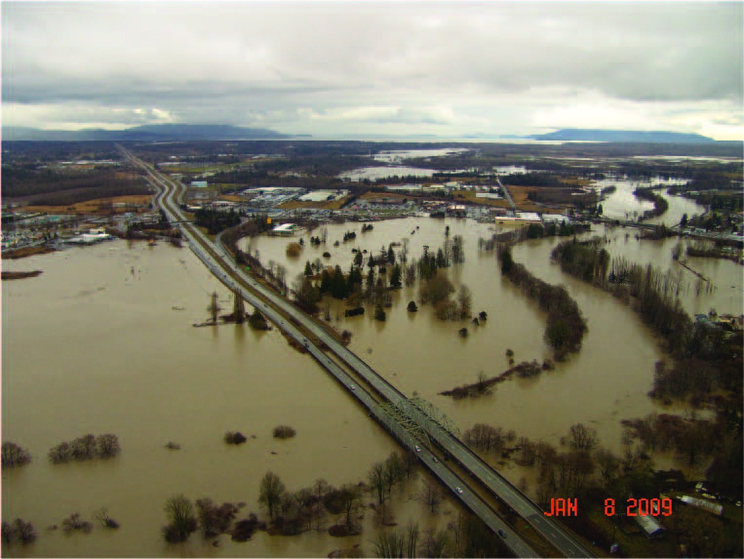
If you’re looking at homes in Whatcom County, sooner or later you’ll hear about the Nooksack River. It runs from the Mount Baker foothills through Deming, Everson, and Lynden, then out past Ferndale to Bellingham Bay. It’s a big part of why the farmland out here is so good. It also floods.
I’m Jeff Engen, a broker here in Bellingham. I’ve been licensed since 2021 and I’ve helped nearly 200 families buy and sell homes in Whatcom County. Here’s what I tell every buyer who’s looking near a river, a creek, or the shoreline.
Some properties are affected, and the vast majority are not. The important thing is to know what you’re signing up for before you make an offer. Good decisions start with good information.
This guide walks you through how to check a home’s flood zone, what records to ask for, and what questions to bring to an insurance professional. Full disclosure: I’m a broker, not an insurance agent or an attorney, so I’ll point you to the official sources and the right people for those answers.
How common is flood risk in Whatcom County?
Less common than people fear, but real in certain places.
Redfin shows flood risk data from First Street’s Flood Factor model. As of October 24, 2026:
- Whatcom County: about 5% of properties, or 4,502, are at risk of severe flooding over the next 30 years. Redfin rates the county’s overall risk as moderate.
- City of Bellingham: about 2% of properties, or 314, are at risk of severe flooding over the next 30 years. Redfin rates the city’s overall risk as minor.
That’s an important distinction. FEMA’s official flood maps and First Street’s model are separate assessments, and they won’t always agree on a specific home. For lending and insurance requirements, the FEMA map is the one that counts. For your own decision, it’s worth looking at both.
Where flooding happens here
In Whatcom County, flood risk mostly follows water. Whatcom County lists three main settings for flood zones:
- Rivers, streams, and ditches. The Nooksack and its forks, plus the Sumas River, are the big ones. When the Nooksack overflows near Everson, water can run north toward Sumas, which is why flood planning here now crosses the border.
- Lakes and wetlands. Low ground near lakes and wetlands can flood in long, heavy rains.
- Coastal beaches. Shoreline areas can flood when a high tide lines up with a storm.
In my experience, the parts of the county that see flooding most often are along the Nooksack around Everson and Nooksack. Some areas of Ferndale and Lynden, which both sit along the Nooksack too, see it as well. In Bellingham, it’s usually isolated, low-lying parts of town. That lines up with the County’s own records: its flood recovery page names Everson, Nooksack, and Sumas as the places hit hardest in recent river floods. Even in those towns, a lot depends on the specific lot, so always check the address on the FEMA map (step 1 below).
Inside Bellingham, flooding in big storms has mostly come from creeks such as Whatcom Creek and Squalicum Creek, and from low streets near the waterfront.
Recent floods worth knowing about
I’m sharing these so you understand the history, not to steer anyone away from a town. Flood risk can vary a lot from one property to the next, even within the same town, which is why the address-level steps below matter.
November 2021. Over November 13 to 15, a National Weather Service gauge in Bellingham recorded 5.57 inches of rain in under 72 hours. The Nooksack overtopped its levee at Everson on the night of November 14 to 15 and flooded Everson, Nooksack, and Sumas. The National Weather Service reported water damage to more than 85% of homes in Sumas. Landslides closed I-5 south of Bellingham for more than a day, and the river flooded again at the end of the month.
In Bellingham that same month, the City closed streets including Iowa Street at I-5 and Squalicum Parkway as creeks rose.
I talk about the 2021 floods in my Bellingham weather video, starting right at that part:
December 2022. On December 27, 2022, a king tide combined with storm surge to flood shoreline areas. Local reporting described flooded roads at Sandy Point, flooding along Terrell Creek near Birch Bay, and road closures in Bellingham including Roeder Avenue and Squalicum Way.
December 2025. According to Whatcom County, a series of atmospheric rivers caused the Nooksack and its tributaries to overflow, with major flooding along the river corridor, particularly in Everson, Nooksack, and Sumas. The County’s Flood Recovery Information page still lists recovery resources.
For more on our weather overall, including what a normal winter looks like, see my Bellingham weather guide.
What a “flood zone” actually means
When people say a home is “in a flood zone,” they usually mean FEMA’s map shows it in a Special Flood Hazard Area. Here are the basics, straight from FEMA and its FloodSmart program:
- High-risk areas are zones that begin with the letter A or V. These areas have at least a 1% chance of flooding in any given year. That works out to at least a 1-in-4 chance of flooding over a 30-year mortgage.
- Moderate-to-low-risk areas are zones B, C, and X.
- There’s no “no-risk” zone. From 2014 to 2024, nearly one-third of flood insurance claims through the National Flood Insurance Program came from outside high-risk areas.
- The 100-year floodplain is another name for that 1% annual chance area. Whatcom County’s maps also show the floodway, which is the river channel plus the nearby land that has to stay open to carry floodwater.
One thing I always tell buyers is that “100-year flood” doesn’t mean once every 100 years. It’s a 1% chance every year.
How to check a home’s flood zone, step by step
Here’s the process I use with my clients. You can start most of it from your couch.
1. Look up the address on FEMA’s flood map
Go to the FEMA Flood Map Service Center at msc.fema.gov and search the address. You’ll see the official flood map panel and the zone for that spot. Look at the whole lot, not just the house. A driveway, barn, or septic drainfield can sit in a different zone than the home.
2. Check Whatcom County’s records (unincorporated areas)
For homes outside city limits, Whatcom County’s River and Flood team is a great resource. According to the County, you can request a flood map for a property you own or are considering buying, at no cost. The County also publishes a FEMA flood layer on its online maps.
Whatcom County River and Flood: 360-778-6230, [email protected], 322 N Commercial Street, Bellingham.
3. Check City of Bellingham records (inside city limits)
Inside Bellingham, the City uses FEMA’s Flood Insurance Study for Whatcom County and Incorporated Areas (dated January 18, 2019) and the matching flood maps. Those are on file at the City’s Permit Center at 210 Lottie Street. Other cities in the county, like Ferndale, Lynden, Everson, and Sumas, keep their own floodplain records, so ask the city where the home sits.
4. Read the seller disclosure closely
Washington’s seller disclosure statement, Form 17, asks about flooding, standing water, and drainage problems, past damage from floods, and whether any part of the property is in a floodplain. It also asks if a basement has flooded or leaked. You have three business days after you receive it to approve it or rescind. Read those answers carefully and ask follow-up questions in writing.
5. Ask for an elevation certificate
An elevation certificate is a form completed by a licensed surveyor, engineer, or architect. It shows how high the home sits compared with the base flood elevation, which is how high floodwater is expected to rise in a 1% annual chance flood.
The seller may already have one. The local floodplain office may have one on file, too. If not, you can hire a surveyor to prepare one. It’s often the single most useful document for understanding a home’s flood risk and for getting an accurate insurance quote.
6. Ask about the home’s flood history
Beyond Form 17, I ask the listing broker:
- Has the home or the land ever flooded? When, and how deep?
- Were any repairs or permits pulled after a flood?
- Has the home been elevated, or have the furnace, water heater, and electrical panel been raised?
- Does the seller have a current flood insurance policy, and what does it cost?
Side note: if a home in a mapped floodplain was badly damaged, local rules can require major changes. Whatcom County explains that when repair costs reach 50% or more of a structure’s value, it’s considered “substantially damaged” and generally has to be elevated, replaced, or moved to meet current standards. That’s worth knowing about any home with a past flood.
7. Get a flood insurance quote before you’re locked in
Do this early, ideally before you make an offer and no later than your inspection period. Flood insurance costs vary a lot from one home to the next, and the quote can change how you feel about a property.
I talk about flood zones around Lynden in my full Lynden tour, starting right at that part:
Flood insurance basics to know before you talk to an agent
I’m not giving insurance advice here. These are general facts from FEMA and the Washington State Office of the Insurance Commissioner, so you know what to ask.
- Most homeowners policies don’t cover flood. Flood is a separate policy.
- Lenders may require it. If the home is in a high-risk area and you have a government-backed mortgage, you’ll be required to buy flood insurance.
- There are two main sources. The National Flood Insurance Program (NFIP) sells policies through insurance agents, and private and surplus lines insurers also offer flood coverage.
- NFIP has limits. NFIP building coverage goes up to $250,000 and contents up to $100,000. Some buyers look at excess coverage above that.
- There’s usually a waiting period. NFIP policies generally take 30 days to start, with exceptions, including when the policy is bought in connection with a mortgage for a home purchase.
- Elevation matters. Your home’s elevation, foundation type, and where the utilities sit can all affect the price, and an elevation certificate can sometimes help lower it.
- Community discounts. Whatcom County takes part in FEMA’s Community Rating System, and the County says that gives residents of unincorporated Whatcom County a 20% reduced flood insurance rate.
My advice is simple. Talk to a licensed insurance professional about the specific home before you commit. The Washington State Office of the Insurance Commissioner also has a consumer advocacy line at 1-800-562-6900 if you have questions about coverage.
What’s being done about flooding
Whatcom County and its partners are working on long-term flood planning for the Nooksack. A few efforts you’ll hear about:
- Floodplain Integrated Planning (FLIP) for the Nooksack River.
- Everson Flow Split planning, which looks at the overflow path from the Nooksack near Everson.
- The Transboundary Flood Initiative, signed in October 2023 by Washington State, British Columbia, Tribes and First Nations, Whatcom County, and the City of Abbotsford.
Lynden’s Pepin Creek project (the Double Ditch Road ditches)
If you’ve driven Double Ditch Road or Benson Road in Lynden during a heavy rain, you’ve probably seen the roadside ditches running full. That’s Pepin Creek. Right now it runs through those roadside ditches, and they struggle to keep up when it really pours.
The City of Lynden plans to move the creek out of the ditches and into a new, natural stream corridor between Double Ditch and Benson Roads, built with enough room to carry higher flood flows, plus fish-passable bridges in place of old culverts. The first bridge over the new channel, on Main Street, is already built. The rest is being phased in, so if you’re looking at homes in that part of Lynden, ask how the project timeline affects the property. (Source: City of Lynden, Pepin Creek Relocation white paper.)
I cover this in my video on the area’s biggest megaprojects, starting right at the Pepin Creek part:
The County also mails an annual “Flooding in Whatcom County” newsletter to owners of flood-prone properties each fall. If you buy near the river, it’s worth reading.
Should you avoid buying in a flood zone?
Not necessarily. For the right buyer, a home in or near a mapped floodplain can make sense. Some of the most beautiful farmland and river views in the county come with some flood risk.
The trade-offs are real, though. You may pay for flood insurance, you may face extra rules if you remodel, and you’ll want a plan for high water. What I don’t want is for anyone to find out after closing. That’s the whole point of checking first.
If you’re comparing towns, you can read more about Lynden, Ferndale, Everson, and Blaine on my community pages. A side-by-side comparison of Ferndale, Lynden, and Blaine is coming soon. I’m also writing about Birch Bay, including its shoreline, coming soon.
Buying from out of state? My guide to buying a home in Whatcom County from out of state covers how I check flood zones and other local issues for clients who can’t be here. And if you’re still deciding where to land, start with my complete guide to moving to Bellingham.
Frequently asked questions about Whatcom County flood zone homes
How do I find out if a Whatcom County home is in a flood zone?
Search the address on FEMA’s Flood Map Service Center at msc.fema.gov. For homes in unincorporated Whatcom County, you can also request a flood map from Whatcom County River and Flood at no cost. Inside Bellingham, the flood maps are on file at the City’s Permit Center.
What does flood zone A or AE mean?
Zones that begin with A or V are FEMA’s high-risk areas, also called Special Flood Hazard Areas. They have at least a 1% chance of flooding each year, or at least a 1-in-4 chance over a 30-year mortgage.
Do I need flood insurance to buy a home in a flood zone?
If the home is in a high-risk area and you have a government-backed mortgage, flood insurance is required. Even when it isn’t required, most homeowners policies don’t cover flood. Talk to a licensed insurance professional about the specific home.
What is an elevation certificate?
It’s a form completed by a licensed surveyor, engineer, or architect that shows a building’s elevation compared with the base flood elevation. It can help you understand a home’s flood risk and may affect insurance pricing. Ask the seller or the local floodplain office if one is already on file.
Does the seller have to disclose flooding in Washington?
Washington’s seller disclosure statement, Form 17, asks about flooding, standing water, drainage problems, past flood damage, and whether the property is in a floodplain. Buyers have three business days after receiving it to approve it or rescind.
Which parts of Whatcom County flooded recently?
In November 2021 and again in December 2025, the Nooksack River flooded parts of the river corridor, particularly Everson, Nooksack, and Sumas. In December 2022, a king tide and storm surge flooded some shoreline areas. Flood risk is still limited to a small share of the county. Redfin’s Flood Factor data puts about 5% of Whatcom County properties at risk of severe flooding over 30 years.
Let’s look at the map together
If you’ve found a home near the river or the water and want a second set of eyes on the flood map, send me the address. I’ll pull what I can, show you where to look, and help you line up the right questions for an insurance professional. You can also learn more about how I work on my buy with us page.
Whether you’re moving next month or two years from now, I’d love to help. Call, text, or email anytime.
- Call or text: 360-393-9783
- Book a call: calendly.com/jeffengenrealestate
- Find your fit: bellinghamquiz.com
- Watch more: Moving To Bellingham Washington on YouTube
Jeff Engen, Broker | Jeff Engen Real Estate | MJB Real Estate Group | 310 E Magnolia Street #201, Bellingham, WA 98225 | 360-393-9783 | [email protected]
 Information is deemed reliable but not guaranteed. Market statistics are from NWMLS and are subject to change. This article is general information, not tax or legal advice.